Satellite imagery gapfilling
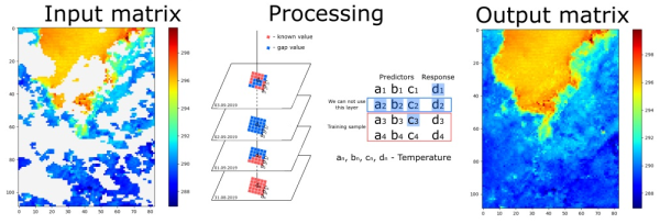
During my work at Hydrological Institute I proposed a hypothesis about posibility to reconstruct gaps (e.g. clouds) in remote sensing imagery by establishing relationships between pixels based on archived data and machine learning techniques.
We have implemented opensource software toolbox and test it for different datasets: LST, Albedo, NDVI. Optimistic results were obtained, and I used this algorithm when creating a continuous series of various parameters of the Earth’s surface
You can learn more in the published article.